


Montagne de Siguret

orsel
User GUIDE

Length
13.7 km

Max alt
2600 m

Uphill gradient
1025 m
Km-Effort
27 km

Min alt
1633 m

Downhill gradient
1021 m
Boucle
Yes
Creation date :
2022-07-10 06:39:09.556
Updated on :
2022-07-10 15:43:22.538
7h31
Difficulty : Medium

FREE GPS app for hiking
 SityTrail
IGN / Geographical institutes
SityTrail Plus
The world is yours!
About
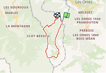
Trail Walking of 13.7 km to be discovered at Provence-Alpes-Côte d'Azur, Hautes-Alpes, Les Orres. This trail is proposed by orsel.
Description
Belle boucle
Positioning
Country:
France
Region :
Provence-Alpes-Côte d'Azur
Department/Province :
Hautes-Alpes
Municipality :
Les Orres
Location:
Unknown
Start:(Dec)
Start:(UTM)
303326 ; 4930093 (32T) N.
Comments